During installation of a sewer line, the remains of an iron forge mill were discovered. Drilling equipment became lodged in the base of the foundation nearly 8 feet below the surface.
Due to the discovery, there was immediate emergency consultation between the Maryland Historical Trust (MHT), Department of Natural Resources (DNR) and Maryland Aviation Administration (MAA), which operates BWI Marshall. In order to continue the sewer installation, archaeologists were called in to document the features visible above ground and monitor construction activities to record additional features as they were exposed. Upon completion of the archaeological field study, the forge foundation and ruins were removed.
The project vicinity has been known since historic times for its rich mineral resources, particularly iron.
The iron forge mill was part of a complex of industrial buildings and features that may have been in operation as early as the mid- to late 1700’s. Identified features included: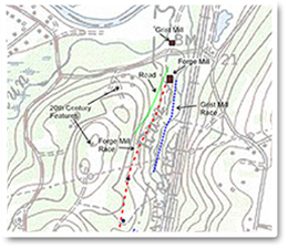
- The forge mill foundation and its associated wheel pit and headrace
- The foundation of Selby Mill, a grist mill, and its associated headrace
- Road traces
Forge Mill Building
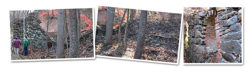
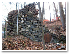
The forge mill building was built into the east face of a hillside. In plan, the foundation was 38×68’, although a “shelf” within the soil slumping into the north end foundation may indicate the presence of the north wall, which would reduce the building size to 38×56’. The building remains that were visible above the surface included mortared stone walls on the south and east sides. A segment of mortared stone uncovered just below the surface during tree removal may represent a segment of the west wall, suggesting that all four walls were stone.
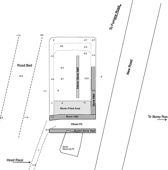
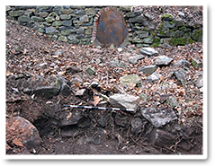
A wheel pit is located on the southern end of the building foundation. The outer wall of the wheel pit was represented by a stone wall approximately 8’ south of the south foundation wall. A headrace directed water in the wheel pit from its southwest corner.
The east and south foundation walls were composed of cut and natural stones held together with a sandy mortar, which had nearly decomposed. Large, finished cut stones were primarily used on the exterior faces of the building, while smaller cut and natural stones formed the interior facades. 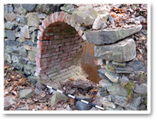 The cores of the walls appeared to be composed of smaller natural stones much less carefully arranged than on the faces.
At the time of the initial field investigation, portions of the south foundation wall remained to a maximum height of 15’ above the ground surface. The south wall was approximately 4’ thick. The western 15’ of the south wall curved outward, to the south. This may have been done to guide water entering the wheel pit from the race.
An oval-shaped brick-lined opening was present within the south foundation wall, 14’ from the southeast corner. The brick opening was not centered within the wall. The opening measured approximately 2.5 by 3.5 feet. It likely held the wheel shaft, which would have driven hammers and possibly bellows on the interior of the forge.
 The east foundation wall was approximately 3.5 feet thick and of similar construction to the south wall. The east wall had been robbed of materials at some point. Based on evidence of stones removed from the tie-in with the south wall, the east wall was likely stone to the same height as the south wall. A portion of the interior face of the east foundation was visible approximately 25 feet north of the southeast corner. The foundation rose 2’ above the interior ground surface. When initial field investigation took place, the outer face of the remaining wall was obscured under a linear mound of soil. During removal of a large tree, the outer face of the west wall was exposed to more than 3’ above the ground surface on the exterior of the foundation.
 Removal of a segment of the east wall during installation of the sewer line exposed a cross-section of the eastern wall and associated soils. The various strata indicate at least one incidence of wall collapse and perhaps a robbing episode. One closely resembled the natural subsoil, but it contained artifacts, which suggests that is was a historic fill. A sample of the artifacts that were dislodged during cleanup was cataloged. Artifacts included one window glass, two hand wrought bolts, nails and oyster shell. The identifiable nails appeared to be machine cut (circa 1790-1800). Other observed artifacts included a large hinge and significant amounts of window glass and slag.
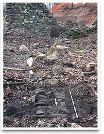
In addition to the outer foundation walls of the forge building, two interior stone features were uncovered during tree removal and sewer installation activities. An interior stone wall was identified in line with the brick-lined opening and running north-south for 23’. The southern end of the wall was disturbed by the growth of a large tree and the north end was obscured below slumped soil. The wall was 2’ wide and composed of relatively small stone, most of which did not appear to have been cut.
 A concentration of stone, possibly representing a stone platform, was identified on the southern end of the foundation interior. Mechanical excavation revealed that orange subsoil was present just below the surface within the feature interior, with the exception of a 9-foot section adjacent to the south foundation wall. This area was filled with stone, possibly originally organized as a stone wall or platform. Alternatively, a hole may have been present here, which collected stone as portions of the south wall collapsed. If a platform was present, it was not tied into the foundation walls. Stone extended to a depth of approximately 6’, at which point subsoil was encountered.
Few artifacts were observed on the site other than architectural remains. Architectural artifacts included stone, brick and window glass. All of the brick appeared to be hand made. Some small rectangular limestone blocks were present on the surface of the interior of the building. Other artifacts observed included slag, a bolt and an iron strap. Most slag fragments were fist sized or smaller, although some fragments were more than 1 foot square.
Wheel Pit, Headrace and Road
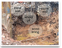 The wheel pit was located adjacent to the outside of the south foundation wall. It was defined by that wall and a second stone wall approximately 8 feet to the south. The outer wall was constructed of mortared stone and was approximately 3.5 feet in width. It was of similar construction to the south wall of the foundation, although it did not appear to extend to the same depth as the foundation. The bottom of the wheel pit was lined with wooden planks.
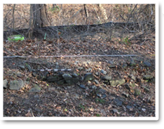
 A headrace guided water from a mill pond downhill to the water wheel, powering the forge mill. The headrace drops down just before the southwest corner of the forge into the wheel pit. After leaving the wheel pit, water likely was channeled into Stony Run or possibly into the headrace for Selby Mill. The forge mill race is approximately 4-5 feet wide and bermed on the downhill (east) side. Road from the forge.The race appeared to originate at an east-west drainage running into Stony Run, which may have been dammed to form a mill pond. No evidence of a dam or mill pond was found, however.
 A road trace runs approximately north-south on the west side of and above the forge and headrace. For most of its length the road parallels the race. The road is nearly 20 feet wide close to the forge and gradually narrows to the south.