12 Miles of Family Fun Brought to You by the MAA
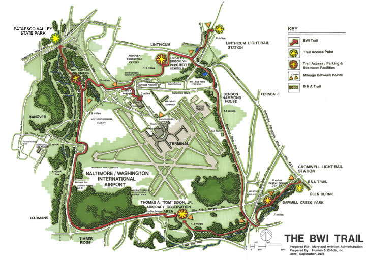
The BWI Hiker-Biker Trail is a 12.5 mile trail that encircles the BWI airport and connects hikers, bicyclists, walkers, and joggers to community resources, public transportation, and area attractions. Most of the trail has an asphalt surface, however, wooden boardwalks were used in environmentally sensitive areas to protect natural features.
The trail was built and is maintained through a public/private cooperative effort that included the Maryland Aviation Administration, in association with the Anne Arundel County Department of Recreation and Parks and the State Highway Administration.
Beginning at the Linthicum light rail station, the trail runs past the historic Benson-Hammond House, and continues along Aviation Boulevard to the Stewart Avenue Bridge. At the bridge, trail users have two options: continuing over the bridge for connection to the B&A Trail or the Cromwell light rail station; or, traveling west to the Thomas A. Dixon, Jr. aircraft observation area where there is a tot-lot, bike racks, and rest rooms.
From the observation area, the trail crosses over airport property at the intersection of Rt. 176 and WB&A Road. The trail continues up the west side of Rt. 170 and completes the loop around the airport to the west and north. Connections to the BWI MARC / Amtrak rail station, the Maryland Department of Transportation headquarters, and other spur trails to the north can be made from this area.
Parking for the trail is available at the Tom Dixon Aircraft Observation Area, Sawmill Creek Park, and the Linthicum and Cromwell Light Rail stations.