Can aircraft fly over my house? Yes.
Can aircraft overfly densely populated areas? Yes.
Can aircraft at BWI Marshall operate at night or in the early morning hours? Yes.
Can MDOT MAA restrict where aircraft fly and when? No.
Can MDOT MAA restrict certain aircraft that operate at BWI Marshall? No.
Can MDOT MAA turn down a carrier that wishes to operate at BWI Marshall? No.
Can MDOT MAA dictate aircraft arrival or departure times? No.
Can aircraft deviate from noise abatement procedures? Yes.
Can MDOT MAA fine an airline for not complying with the noise abatement procedures? No.
BWI Marshall Airport is owned and operated by the Maryland Department of Transportation Maryland Aviation Administration (MDOT MAA) on behalf of the State of Maryland.
MDOT MAA fosters the vitality of aviation statewide and promotes safe and efficient operations, economic viability and environmental stewardship. MDOT MAA is responsible for the operation of Baltimore/Washington International Thurgood Marshall and Martin State airports. MDOT MAA provides friendly, convenient facilities and customer services and develops enhanced domestic and international passenger and cargo opportunities through inter-modalism and state-of-the-art technology.
MDOT MAA is responsible for the operation and maintenance of BWI Marshall facilities, including runways and taxiways. MDOT MAA is required to ensure that all facilities meet FAA regulations. Commercial pilots fly prescribed routes to and from BWI Marshall Airport as instructed by air traffic controllers. The FAA is responsible for managing BWI Marshall Airport’s airspace and for ensuring the safe and expeditious flow of traffic. Flight path procedures are dictated by the FAA, taking into account considerations of operational, safety, and air traffic control procedures. The ultimate authority of the aircraft rests with the pilot.
The Noise Section of the Office of Environmental Services is committed to monitoring aircraft operations and airport related noise levels in the communities surrounding BWI Marshall and Martin State Airports, and is dedicated to helping stakeholders understand the facts, science, and regulations associated with airport noise in a transparent, clear and accessible way to those we serve.
No. The FAA controls and regulates the airspace. Any change in departure or arrival flight paths must be approved and implemented by the FAA.
The FAA is the sole organization in the United States responsible for the movement of aircraft both on the ground and in the air. The FAA is also responsible for designing air travel routes and procedures, including the standards for lateral and vertical separation between aircraft and determining hazards to flight such as mountains or tall buildings. An airport may advocate for certain noise abatement flight tracks to reduce noise, but these must be both approved and assigned by the FAA.
MDOT MAA provides multiple methods to submit aircraft noise complaints. The primary methods include an on-line form, WebTrak, and a 24-hour noise complaint and information hotline (410-859-7021). MDOT MAA accepts and logs complaints from many sources including third-party apps, but does not control any third-party noise complaint apps. More information is available here.
All Complaints are logged daily into a complaint database. This information is compiled and reported quarterly.
The Noise Section investigates complaints by new callers and callers who desire specific information about noise events and aircraft activity. Although all aircraft noise complaints are documented daily and reported on quarterly, staff does not typically investigate every complaint made by frequent callers due to the often-repetitive nature of the complaint.
Filing a complaint will not bring about an individual’s desired change, rather it provides a means for the Airport to gather information, report, and disseminate the information to the FAA, airlines, public, and local representatives.
NextGen is the FAA’s action plan to modernize the national airspace system. This effort is composed of many different programs and initiatives including the use of satellite-based technology. More information on NextGen is available on the FAA’s NextGen homepage at https://www.faa.gov/nextgen/.
In 2014 the FAA began to roll out a number of performance-based navigation procedures for aircraft arriving and departing BWI Marshall Airport. These procedures use satellite technology to provide more precise positional information to the pilot and air traffic controllers, increasing the margin of safety and efficiency of the airspace.
The implementation of NextGen led to a considerable increase in noise complaints at BWI Marshall. As a result, MDOT MAA supported the facilitation of a community roundtable, the DC Metroplex BWI Community Roundtable, comprised of community members and industry. The Community Roundtable has met continuously since 2017 and has worked tirelessly to effect change.
For more information on the Roundtable click HERE.
Additionally, MDOT MAA manages the Homeowners Assistance Program which has historically included the Residential Sound Insulation Program, Resale Assurance Program, and a Voluntary Acquisition Program. The Homeowners Assistance Program is currently on hiatus as MDOT MAA prepares for the next phase of the Residential Sound Insulation Program which is anticipated to begin in 2020. The Resale Assurance Program was concluded in 2008.
More information on these programs can be found HERE.
DNL (Ldn) stands for Day-Night Average Sound Level and is used to describe the cumulative noise exposure during an average annual day. DNL does not represent the sound level heard at any particular time, but rather represents the total sound exposure.
BWI Marshall Airport operates 24 hours per day 365 days per year. There is no nighttime curfew at the Airport.
Due to the large number of flights that operate out of BWI Marshall, most areas within 30 miles of the Airport will have times when flights go overhead. Where and when this occurs will depend on which runways and traffic flows are in use. However, areas located directly off the ends of runways can expect to have air traffic pass overhead as aircraft land or depart. The line of arriving flights can extend up to 15 or 20 miles out from the end of a runway. Flying over residential areas is not prohibited.
Contact the BWI Marshall Airport Noise Section prior to a home purchase when there are concerns regarding aircraft noise. The Noise Section can discuss your concerns, provide graphics depicting aircraft flight tracks and altitudes relative to property locations, and provide aircraft and community noise data. Please note, Noise Section staff can offer no opinion as to whether or not a home should be purchased.
Typical helicopter operations tend to be related to the military, media, medical flights, or with law enforcement and therefore, are not required to maintain any particular altitude. Take notice that most helicopter flights do not originate or terminate at BWI Marshall. Helicopters may fly below minimum altitude requirements if the operation is conducted without hazard to persons or property on the ground.
BWI Marshall Airport maintains three runways. Runway 10/28 is oriented in an east/west direction and is BWI Marshall Airport’s longest at 10,502 feet in length. Runway 15R/33L is 9,500 feet in length. Runway 15L/33R is 5,000 feet in length and can only be used by certain aircraft. Runway 4/22 was permanently closed on August 6, 2014.
To understand the naming convention used for runways, note that each pair of numbers corresponds to the name of each runway end. The numbers are a shorthand notation that indicates the runway’s geographical orientation: the compass heading of the runway, rounded to the nearest ten degrees, with the trailing zero dropped. For example, the magnetic heading of Runway 28 is approximately 284 degrees. The number is rounded to 280, and finally to 28 with the zero dropped; hence, Runway 28. Simple geometry requires that the difference between the designation of each end equals 18 (that is, 180 degrees); hence, Runway 10 is in the opposite direction from Runway 28.
A preferential runway system is a local traffic control procedure that identifies a specific runway for use when specific conditions are present. The MDOT MAA maintains a preferential runway use program to minimize the aircraft noise impact on neighboring communities. For noise abatement purposes, west flow, which concentrate turbojet departures on Runway 28, are preferred.
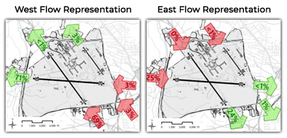
Prevailing wind speed, direction and weather factors determine the direction of air traffic flow. Aircraft usually take off and land into the wind to meet safety and operational requirements. BWI Marshall typically operates in one of two configurations, based on wind and weather conditions. During west flow, all jet aircraft primarily depart from Runway 28 and arrive on Runway 33L. Historical trends result in annual average west flow of about 70%. During east flow, all jet aircraft primarily depart from Runway 15R and arrive on Runway 10. Historical trends result in annual average east flow of about 30%.

There are a number of factors that influence noise levels from aircraft overflights. Noise levels from different types of aircraft varies, based on the number and type of engines, the size of the aircraft, and the type of operation (arrival, departure, or overflight). Weather factors, such as temperature, humidity, the type and amount of cloud cover, wind speed and direction all influence the propagation of sound. In general, hot and humid weather reduces an aircraft’s ability to climb quickly, resulting in aircraft that are lower to the ground and louder. Scenarios of low dense clouds can cause a thermal inversion, which reflects noise back down to earth.
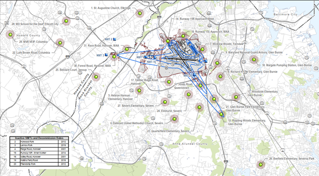
MDOT MAA has a permanent noise and operations monitoring system. Staff has access to ANOMS (Airport Noise and Operations Monitoring System) including 24 state-of-the-art permanent and three portable noise monitors. ANOMS provides reliable airport operations data, archives data for future airport decisions, validates complaint information, tracks effects of air traffic routing procedures, and validates computer-generated noise models.
https://webtrak.emsbk.com/bwi3

MDOT MAA: Maryland Department of Transportation Maryland Aviation Administration
FAA: Federal Aviation Administration
NAS: National Airspace System
PBN: Performance Based Navigation
Roundtable: DC Metroplex BWI Community Roundtable
DNL (Ldn): Day-Night Average Sound Level
